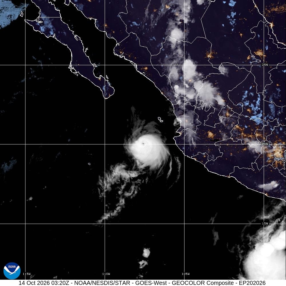
The Hurricane Simon Mexico forecast was revised upward at 03:00 UTC on 14 October 2026, or 04:00 BST, with maximum sustained winds estimated at 110mph (175km/h). The US National Hurricane Center kept a hurricane watch for Las Islas Marias and warned that people in west-central Mexico and Baja California Sur should monitor further updates.
Last updated: 14 October 2026, 05:15 BST. Sources checked during preparation.
Hurricane Simon, 14 October 2026, 03:20 UTC (04:20 BST). GOES-18 GeoColor imagery: CIRA/NOAA, via NOAA NESDIS STAR. Nighttime multispectral product, not a ground-level photograph; its city-light layer is static, not a live observation. US Government material is public domain unless otherwise marked. Reproduced without editorial alteration; WordPress supplies resized versions.
At a glance
- The centre was about 200km west of Cabo Corrientes and southwest of Las Islas Marias.
- Simon was drifting west at approximately 2mph; its future track is uncertain.
- The island hurricane watch means conditions are possible, not already occurring everywhere on the mainland.
- Dangerous surf and rip currents can affect the coast beyond the compact wind core.
Hurricane Simon Mexico forecast: what is new?
NHC public advisory 27, dated 8pm MST on 13 October locally, raises the sustained-wind estimate to 110mph. Its 03:00 UTC timestamp places the same update early on 14 October in Britain. These are two time-zone descriptions of one advisory, not separate developments.
The alert says hurricane conditions are possible around Las Islas Marias on Thursday. It forecasts 1–2 inches of rain, with isolated totals up to 3 inches, over portions of Baja California Sur, Nayarit and Sinaloa. It also warns of potentially life-threatening surf and rip currents along parts of the west-central coast and Baja California Sur.
Why the strongest-wind number is not the whole warning
The accompanying NHC forecast discussion describes a very small hurricane whose steering currents are weak. It reports substantial model differences later in the forecast period and low confidence because of the storm’s size, proximity to land and weak steering.
NHC allows for further strengthening before gradual weakening, but neither the intensity forecast nor a centre-line track should be read as a precise guarantee of conditions at a particular resort. A small wind core is not evidence that nearby beaches are safe: coastal swells are a separate hazard.
What British travellers should do
The FCDO’s Mexico guidance advises monitoring NHC updates and following local authorities and tour operators, including evacuation instructions. That is standing travel guidance, not confirmation of a new nationwide British travel ban caused by Simon.
If travelling in the affected region, check the latest NHC storm page, your hotel or tour operator’s instructions and your airline’s status before changing plans. Do not use this dated snapshot as an evacuation decision or a swimming clearance. This is Pacific weather coverage, not a forecast of a storm reaching Sussex.
Brighton Locals’ view
Our judgement is that the increase in wind strength deserves attention, while the explicitly low-confidence track demands restraint. Reporting the island watch and coastal hazards is more useful than presenting an uncertain future landfall as settled.
What happens next
The advisory schedules an intermediate update for 11pm MST, equivalent to 06:00 UTC or 07:00 BST on 14 October, followed by a complete package at 09:00 UTC. Newer official warnings take precedence over the figures here.
Bottom line
Simon has strengthened, but the next track is not settled. Follow the latest local instructions and coastal warnings, not the wind headline alone.

Leave a Reply